CHAD BASIN AND SAHEL CLIMATE IMPROVEMENT PROJECT BY THE CONGO WATER UPLIFTING OVER THE PLATEAU
Abstract for Taal2007(The 12th World Lake Conference) in Jaipur, India
Topics Classification : Lakes, Wetlands and Climate Change No.147
Presenter and Author : Miyakawa Toshihiko (Mr.) D-164
Address : Shinjuku6-27-46-806, Shinjuku-ku, Tokyo, JAPAN
Email : miyachan@mvj.biglobe.ne.jp
Revised : 25 Nov. 2007
This paper introduces the project outline of the water transfer plan from Congo watershed to Chad basin in Africa to recover boundless green field in Sahel region which had been the rich green area until recently from prehistoric ages.
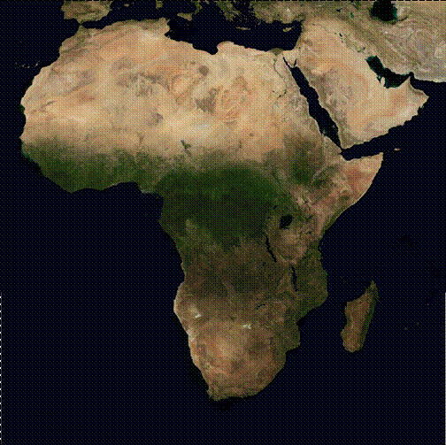
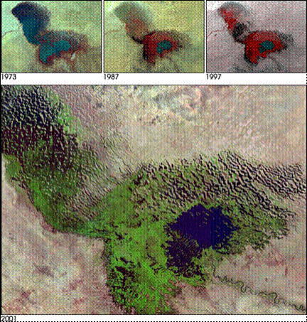
There is a real contrast between the two regions, one is tropical rain forest with more than 40,000 cu. m/sec. water flow and another one is semi-arid or desert with little water. Now the Chad basin is well known in the world that has very serious water shortage and the desertification is expanding year by year. This desertification is not only the regional problem but global affair as a climate change.
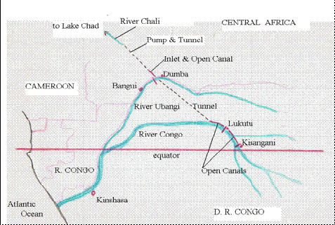
These two large regions are divided by only a rolling plateau in the central part of The Central African Republic (CAR) that is about 500m above sea level. The plateau is only about 200m higher than the Ubangi River, a branch river of Congo, water level at this area. More water will be diverted from main stream of Congo to Ubangi through open canals and tunnels in the progressed phases and the total covered area will be more than millions sq. km.
Progress phases are,
1st : The water flows down to Lake Chad by gravity after crossed the plateau,
2nd : The water pumping up and delivering to surrounding area,
3rd : Tidal force drives the water to westward in flat horizontal great canals with one-way-gates.
All management of this project that are planning, research, survey, funding, design, construction and water management including purchasing, transport, purification, distribution and sales should be controlled by one organization.
The key points are,
1. Establishment of the International NGO,
2. Organize study groups for natural environment and energy resources,
3. Establish revolutionary financial system and ownership for the project,
and so on.
CHAD BASIN AND SAHEL CLIMATE IMPORVEMENT PROJECT BY THE CONGO WATER UPLIFTING OVER THE PLATEAUS
Basic Scheme & Strategy 2007 by Miyakawa Toshihiko
Revised at 25 Nov. 2007
This is the Climate improvement proposal in the Chad basin and Sahel area with delivering mass water from the River Congo, transport distance is 150-1,000km, and by uplifting 100-200m height and over the plateaus in theCentral African Republic. The projected area covers from Central Africa to Sahel region but the beautiful greening results will be influential over the Northern African countries and climate change will be Mediterranean Sea and European Continent finally.
by African Cultural Center
Some reports proposed similar ideas in the past which are not realized or not promoted to execute, but here is more realistic proposal including special organization establishment, solar power supply, engineering solution, environmental recovery and conservation, bio-energy plantation without cropping field reduction, environmental effects for the all people in the region, honored ownership funding system from all over the world and so on.
The project has to be promoted or executed without serious natural hazard or unsuitable phenomenal accumulation in the projected area and/or related fringes. One of the typical feature of this project is it can stop or be canceled anytime if some inconvenient condition happened or observed by the official warning system.
by NASA, USA
The eventual project scheme is very large and the area is extended, but the engineering tasks are not so difficult or no need so high technology and it can implement by the normal or popular existing skills.
South to North Water Transfer in China, under construction
East Line L=1150km 18.0-25.0 billion cu.m/y (571-793cu,m/s)
Middle Line L=1240km 12.5-23.0 billion cu.m/y(396-728cu.m/s)
Pumped Hydropower, Japan & other countries, completed and plan
Kuzuno Ohtuki-city 1.60mkW 280cu.m/s H=714m Tokyo Elec. Co.
Kawaura Gifu-pref. 1.30mkW 270cu.m/s H=578m Chubu Elec. Co.
Kyogoku Hokkaido 0.6mkW 190cu.m/s H=369m
Kannagawa Gunma-pref. 2.82mkW 510cu.m/s H=653m
Komarugawa Miyagi-pref. 1.20mkW 220cu.m/s H=646m
Bath County USA 2,100MW 915cu.m/s H=385m
Kruonis Lithuania 1 600 MW 226 m³/s H=100 m
Tumut 3 Australia 1,500MW H=151m
Only the problem is funding to execute this project because the direct beneficiaries from the project are not so many and not so rich. But this amount which is lacking in detail now is not so huge to startle the world nowadays and it is rather small compared to the Suez or the Panama project at that time. Especially the cost of the starting stage of this project is rather popular water project size in the modern world.
The largest water project in the world now under construction is the South-to-North Water Transfer project in China. This project consists from 3 major projects, the longest way is 1,300km(two of them), and each one carries about 20billion cu.m/year (=600 cu.m/sec) and the total of the 3 projects will sustain 200million people life, many major industries and the green of 400,000sq.km area that is very thickly-populated districts in China.
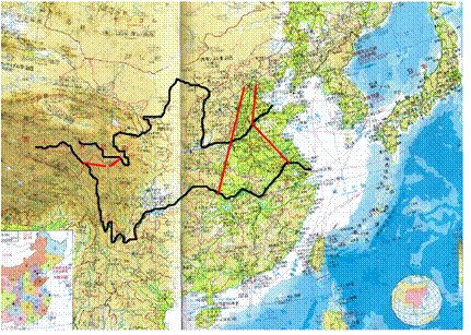
by Teikokushoin, Japan & T.Miyakawa
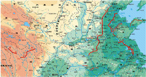
http://www.nsbd.mwr.gov.cn/
The most typical features of this project will be promoted by the special NGO for this project and the new fund management called the Non-refundable and Territory-fixed Investment system. This system prevents from scandals or conflicts between people and/or organization, easy to induce from huge money flows, because any investor can not get back profit from the investment but honored ownership only and the money can not move out from each territory after invested.
This new system will be more effective than donation or grant aid that is already established more than 30years ago as micro credit or microfinance by Prof. Muhammad Yunus and others, but this is macro-finance. Any people in the world can join this system from small money to huge amounts through the NGO. Small money will be pooled up to some amounts that is suitable for a part of the project which is proposed and studied previously by the NGO
The main projects start after study and evaluation from small scheme of 100cu.m/sec water supply to large scheme of 2,000cu.m/sec that is only 5% of Congo water (40,000cu.m/sec or 126billion cu.m/year).
by Miyakawa Toshihiko
The basic scheme and strategies are;
1. Establish an international NGO which is sole agent authorized by all concerned countries and international organization for water control (purchase, deliver and selling), plantation, energy supply and fund management for all related programs. All the money flow is transparent to all people and can traceable by each investor anytime through internet.
2. Research and survey of water resources, natural environment, climate, vegetation, wild animals and others in the projected area before and after the project executed.
3. Study and establishment of plantation standards, forest preservation which is suitable in the region and education for all people in the project related area for most effective green recovery and economical growth.
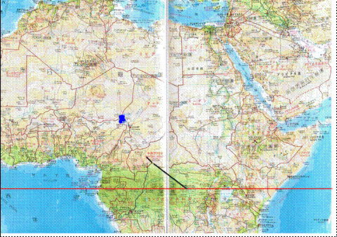
4. Phase I : Take in water at Dumba (El.=351m) or Possel village on the Ubangi river, a branch of Congo, 100km upstream from Bangui city, the capital of Central Africa and lead by open canal (L=20km) and uplift (H=100m+, L=70km) to the most upstream (El.=450-500m) of Chali river main water flow of lake Chad.
5. Phase II : Take in water from Congo main stream at Lukutu city (El=370m) or Kisangani (El.=400m) to Ubangi river through open channels and tunnels (total 600-800km) passing through hills between main stream and Ubangi river. Uplift system expansion is needed for the phase II.
6. Phase III : Water transfer to Western Sahara through horizontal canals (D=10m, W=100-200m) with one-way gates system. The system can drive water toward Western by the tidal phenomenon powered by the lunar gravity called artificial pororoca. This system will be applicable water transfer toward Northern by placing the canal zigzag shape.
7. Energy supply by the solar power cells put on net and sun visor combined system which will be lent to individuals, community, local government and the NGO will procure the power. Place net above several meters height from ground and put solar cells in line on the net with some spaces between lines to pass some sunlight through net. This system has two effects that are power generation selling to the project and acting as sun visor to lower the ground temperature and protect over transpiration from plants and decrease evaporation from ground that means the Climate Improvement. The semi-arid zone and desert will be changed to economical agricultural area by this system and water supply.
8. New investment system called Non-returning and Territory-fixed Investment, similar to The Community Reinvestment in USA, of which profit from the project does not return to any investors and re-invest in each territory for education, health care, rural road and other public property in the original territory, then the territory economics will grow by this project. All the investment can trace any time by each investor through the organization and can check and confirm them by visiting the sites that is called the Honored Ownership.
The profitability from the water supply is vary depend on the climate, soil, crops, vegetation, farmed breed, but a calculation shows 100cu.m/sec water can keep 5,000-10,000sq.km or more area.
NOW A TIME TO START!
I hope many people will join for more study of this project and start up new group to promote it in the near future.
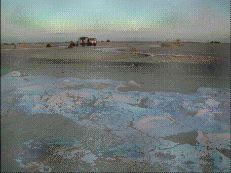
Lake Chad, Now
www.travelpod.com/.../chad_x2x.jpg/YES.html
Thank you.
References,
A study report on African water (in Japanese only), 1986
The Path Between the Seas by David McCullough, USA, 1977
African Cultural Center http://africanculturalcenter.org/
EUMESAT http://www.eumetsat.int/
Min. of Water Resources, P. R. China
http://www.mwr.gov.cn/english1/20040827/39304.asp
Water Resources eAtras http://www.waterandnature.org/eatlas/index.html
Water Resources Institute
http://earthtrends.wri.org/text/water-resources/map-293.html
Wikipedia http://en.wikipedia.org/wiki/Central_African_Republic
Wikipedia http://en.wikipedia.org/wiki/Zaire_River
Maps,
Republique Centrafricaine, Institut Geographique National, France 1993
ONC(Operational Navigation Charts) L-4 Edition4, USA 1988